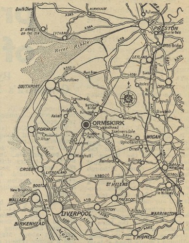
© 1968 Liverpool Daily Post. Based on the Ordnance Survey map; Crown Copyright reserved.
Today’s post also comes from “The Changing Face of Ormskirk”, a supplement published in 1968 in the Liverpool Daily Post.
Looking at an older map of the region shows just how much has changed over the last 40 years. When this was first printed, Skelmersdale had been designated a New Town for just seven years; the railway passing through is still present even though it was axed by Beeching.
The villages marked are quite different to those one would highlight today – Newburgh outclasses Parbold, Mere Brow has been relegated by the rise of Tarleton, Burscough and Burscough Bridge have all but merged into one and I imagine only the people who live say Pinfold rather than Scarisbrick.
The M6 from Warrington to Preston opened five years earlier but the M62, M57, M58, M65, M61 and M55 were just a glint in an over-enthusiastic urban planner’s eye.
Next time we’ll look at what The Changing Face of Ormskirk has to say about Ormskirk town centre itself.
3 responses to “Changing Face of Lancashire Map”
The railway from Skem can’t have been there for much longer – it was gone from Rainford by the time my parents bought their house in 1972 and the tracks will have come up before the estate was built.
Hi Adrian,
I suspect it wasn’t there and they’ve based it on an old OS map. Skelmersdale station was closed in 1963 so I imagine the rails would have been lifted by 1968.
The map also shows the old Cheshire Lines railway running south from Southport then inland to the east of Formby and west of Maghull. I think this route closed in the 1950s. The line of the route close to Southport is now the coast road. Most of the rest is now a multi-purpose trail used by walkers, cyclists and horse riders. I think it is part of the Trans-Pennine cycle route.